The South African Weather Service (SAWS) has issued an urgent series of impact-based warnings for Tuesday, 05 May 2026, as a powerful weather system moves across the country.
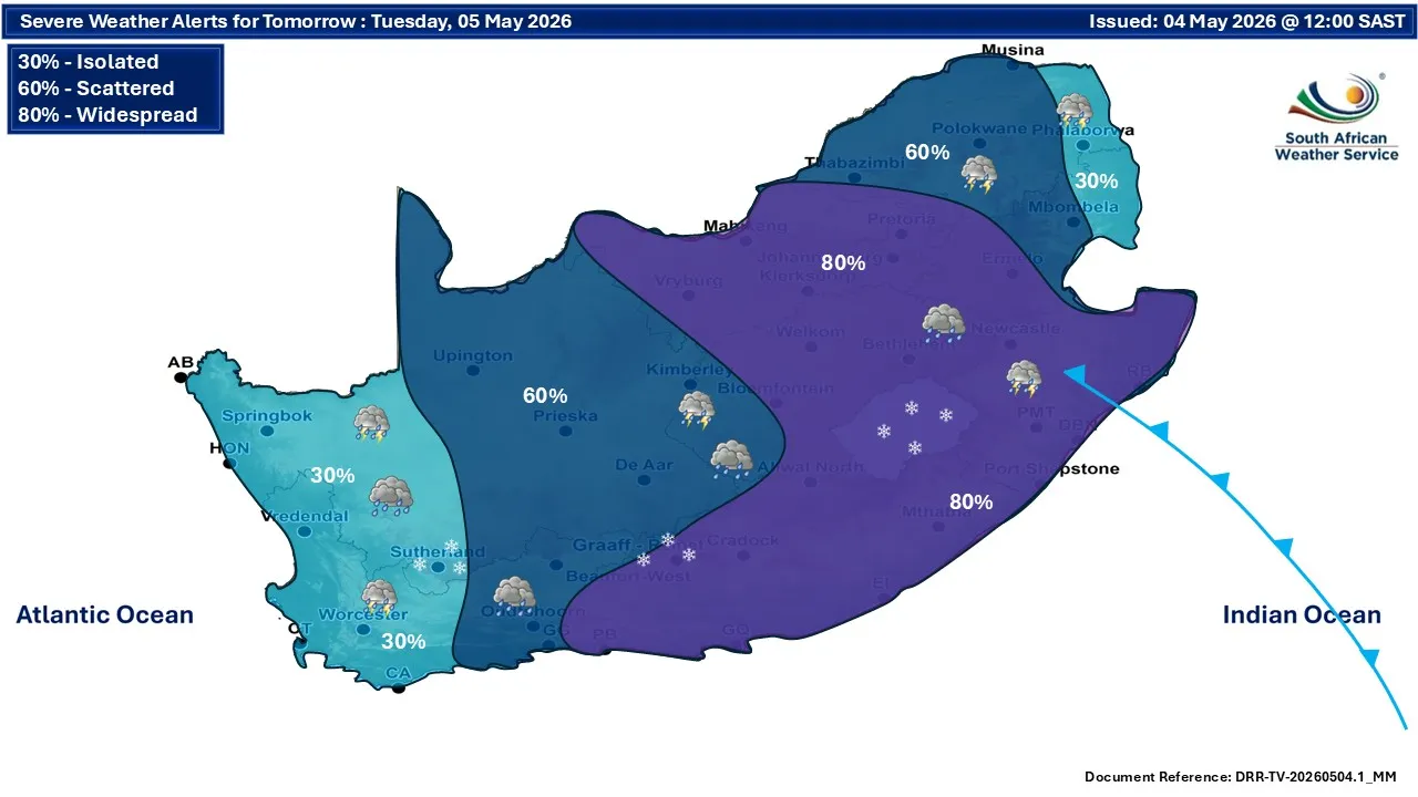
Residents in Gauteng and the central inland provinces are advised to prepare for a significant “widespread” weather event, with an 80% chance of precipitation across the region.
High-Impact Alerts for Gauteng and Surrounding Areas
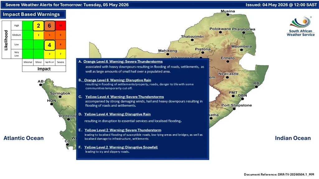
The latest alerts highlight a serious risk for the northeastern interior. Specifically, an Orange Level 6 Warning has been issued for severe thunderstorms and disruptive rain.
For residents in and around Johannesburg and Pretoria, this translates to:
- Flooding Risk: Expect heavy downpours that may result in the flooding of roads, low-lying bridges, and formal or informal settlements.
- Dangerous Conditions: Large amounts of small hail are possible over populated areas, alongside the threat of disruptive rain that could cut off certain communities.
- Infrastructure Impact: Potential damage to property and localized disruption to essential services.
Regional Outlook: From Hail to Snow
While Gauteng sits under the higher-level warnings, the reach of this system is extensive. The SAWS maps indicate varying levels of severity across the inland provinces:
| Alert Level | Warning Type | Expected Impact |
|---|---|---|
| Orange Level 6 | Severe Thunderstorms / Disruptive Rain | Flooding of roads/settlements, danger to life, and large hail. |
| Yellow Level 4 | Severe Thunderstorms / Disruptive Rain | Localized flooding and disruption to essential services. |
| Yellow Level 2 | Severe Thunderstorm / Disruptive Snowfall | Slippery roads due to snow (south-central interior) and localized infrastructure damage. |
Widespread Impact
The forecast model shows a massive “80% Widespread” zone covering the majority of the eastern and central provinces, including Gauteng, Mpumalanga, and parts of the Free State and KwaZulu-Natal. To the west, the intensity tapers off slightly to a 60% scattered risk, while the coastal regions remain at a 30% isolated risk.
Safety Recommendations
Authorities are urging residents to stay indoors and off the roads where possible. Motorists are specifically warned:
- Avoid low-lying bridges: Do not attempt to cross flooded roadways or bridges.
- Secure property: Ensure drainage systems around homes are clear and move vehicles under cover to avoid hail damage.
- Stay Informed: Keep an eye on local news updates as the storm progresses throughout the day.
With the combination of heavy rain and potential snowfall in the higher altitudes of the south-central interior, travel conditions are expected to be hazardous across the inland corridor.